Last Saturday, December 4th, the international Open Data Day took place in conjunction with Random Hacks of Kindness. In 73 cities around the globe groups of people came together to work on open data. In the Netherlands activities took place in Amsterdam and my home town Enschede.

Open Data Enschede

How it came about
In the last days of October David Eaves (open data advocate from Vancouver) first gave voice to the idea of doing local open data events around the world on a single day. Others quickly picked this up. Mid November the Open Government Data Camp in London, hosted by the Open Knowledge Foundation, brought together people from 30 countries, and that was a good opportunity to increase momentum for the international open data hackathon, as we all got to meet face to face. A little over two weeks ago a few civil servants from Enschede, a student and me met up to discuss if we could take part. We had originally met during the Open Innovation Festival in Enschede in June this year, and were looking for a way to take the next step for open data in our city. Previously we boldly had announced a local open data event, but then over the summer organizing it stalled. We agreed that this international open data day might be the trigger we needed to actually do it. Over lunch we settled on a location: the one we were having lunch at, a meeting lounge in the city center with wifi. That afternoon we also brought a website, Open Data Enschede, online announcing our plans. Two of the civil servants involved, Patrick Reijnders and Peter Breukers started asking their colleagues inside city hall for data sets that could be released.


Visualization of cities tweeting about #odhd

Open Data Day
A few days before the event we knew that the work of Patrick and Peter paid off, and that we would have about 25 data sets to work with. The data covered amongst others neighborhood statistics, street names, house numbers, but also the sewage system, geographic height lines, and the location of bus stops and bus routes. We didn’t know how many people would be coming though. As it turned out we had 9 people there for the entire day, entrepreneurs, students, civil servants and an IT-savvy member of the city council, all with coding skills. We were joined for part of the day by about another 10 people. Some of them civil servants involved with information management and geo-information in the city, others from the ITC (international cartography university), as well as the head of the statistics department from the neighboring city Hengelo. This meant lively conversations throughout the day, along with real work being done with the data.
We ended the day with video sessions with the Open Data Day groups in Helsinki (video) and Vienna, talking about the outcomes.
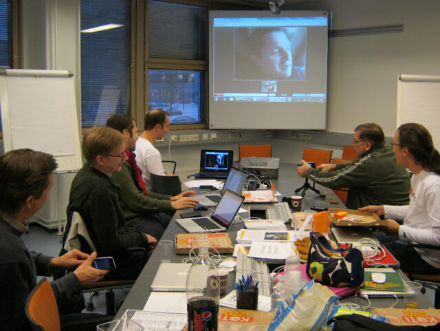


The video session seen from both ends, in Helsinki on the left (photo Irmeli Aro), in Enschede on the right (photo Patrick Reijnders)

Results
For Enschede the Open Data Day was a great success for two main reasons. First of all it meant that a first wave of data sets now has become available. Second, and more important, we have brought together almost 20 people interested in open data, who weren’t aware of each other before (see photos). This is a significant step in creating more momentum in Enschede. A next, more informal, meeting will take place in January 2011 to explore what ideas exist for open data in Enschede, and how to make them reality. The Dutch Data Drinks that Alper started to bring together open data enthusiasts in the Netherlands will get a local chapter, Enschede Data Drinks.
But, of course, like in other participating cities, we also built a few things on Saturday, both currently not more than alpha / demo material though. One is a map of all building permits in the city, with the possibility of accessing the underlying drawings of the building plans, which reuses the building permits data as it is available on the Enschede municipal website. This was build by Robin Janse and Maarten Brouwers, of the Bean Machine.
The other demo maps out companies that went bankrupt for any given post code in the Netherlands, by getting the data from the API of openkvk.nl which in turn re-uses the Dutch trade register. This demo was build by Roy van der Veen.


Photo by Patrick Reijnders, Open Data Hackers at Work

I certainly came away from the day with a lot of energy, and am optimistic about moving open data forward in our city. To help stimulate that I offered the city 11 days of my time in 2011, to work with them on open data and figuring out ways how open data can be of benefit to local government as well. In exchange I don’t want money, but the release of data sets to the public. Let’s see if the city takes me up on my offer!

At the open government data camp recently in London I gave the first of a series of lightning talks, together with Bill Roberts. I chose to address “socially open data”.
For the most part when we are discussing opening up data what open is, it is being defined in terms of technical aspects (formats etc.) and legal aspects (licensing mostly). Where social and organizational
aspects are concerned these are usually seen as part of the adoption process that comes after the release of data, and not as part of how we perceive what open data is. It is being treated as something that
is not connected to the characteristics of the data set itself.
I would like to advocate however that there are certain social aspects that need to be part of how we define ‘open data’. The reason that it is absent in current discussions is I guess because the social side of things is where it can get complex and messy. But we can make that human complexity more managable if we look at it in the scope of singular datasets. On that level it is all about adding context.
Socially open data is data that comes with contextual information, next to the right data formats and open license. Socially open data = just add context.
That context I think can be added in several ways.
Part of it is in what is part of the metadata coming with the dataset:

  • A contact person
  • An address for feedback
  • When was the data generated/collected, and when will it be updated?
  • What was the data used for within government?
  • How was the data used for its government task?
  • How was the data generated / collected?
    (those last three points will tell you a lot about the background / possibilities of a dataset)
    Other aspects have to do with making access to your data more likely:
  • Make data sets findable
  • Point to your data set often (whenever you e.g. cite/use that data yourself)
  • Do PR for your data set
  • Announce your data release in relevant community ‘hang-outs’ (on-line / off-line) of people you think might be interested
  • Add the data set to a data catalogue (like data.gov.uk)
    All these points basically say ‘if you do not make sure people know your data exists and is available, for all intent and purposes it doesn’t and it’s not.’
    And thirdly part of making data socially open is readying the environment for release:
  • Engage in dialogue with likely and emerging re-users. Make them visible if possible in the context of the data set. (this helps new re-users see the potential of the data, and turns the data set into a social object creating new connections)
  • Engage in dialogue with those that the data describes or affects. Make them visible if possible in the context of the data set. (if your data is about agriculture, talk to farmers described by the data about the way/form the data release may be helpful to themselves)
  • Make the release process of data transparent from its inception to its conclusion.
    All of these points help address all kinds of objections and obstacles that may come up when opening up data. All of those, in my experience, can not be dealt with at all on a generic level but only and straightforward in the context of specific data sets. This makes it part of what precedes data release and the data release itself, not the adoption process after release of data.
    By focusing, when defining what open data is, on just the technical and legal aspects we overlook that the needed change of mindset concerning opening government and its data up is only adressed by social aspects. If we leave that out of how we define open data, and relegate it only to what happens after the release of data that is already deemed ‘open’, and not as part of how we get to labeling data as ‘open’, we are simply not addressing the purpose of it all.
    Below are the slides I used at OGD Camp in London to convey my point.

At the Communia Workshop (organized by the Open Knowledge Foundation) yesterday and today we talked about opening up government data sources for the wider public, so others can build their own mash-ups and applications with that data. Most of the existing examples shown were map-based one way or another. That led to some discussion, with some asking why (Google-)maps were so prominent in the examples, and why not focus on some of the other great data sources out there, and others saying that your geographic location is so central to most of what you do that maps are logically the center piece of most mash-ups, and therefore the starting point for opening up government data.


Example of a random Google-maps based representation of information: European Songfestival songs

Now of course, mobile applications are all over geo-data as well, under the collective name of location based services.
I would like to propose a slightly different approach to location based services, by looking at them as context based services (a term I also heard Felix Petersen of Nokia/Plazes use at Shift last fall). Now, your geographic location is always part of your context. But it might not be the most important part of your context in a given situation. Elements in a context are often more interesting because of their relative position to you or each other, not so much because of their absolute position. So let’s make a distinction between geographic location as an important part of my context, and maps.

For me as I write this, it is relevant to know where the nearest Tube-station is, and how far in which general direction I need to walk to get there. I don’t care where exactly on the map I am however. If I had a map, I could infer how far I need to walk etc, but if I can know directly, I do not need to know my location nor a map to see where to go.


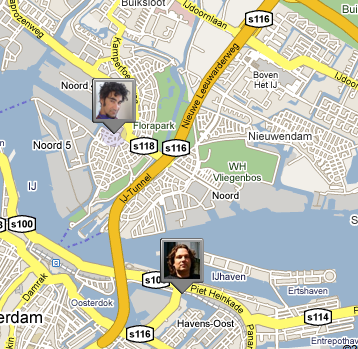
Screenshot of Google Latitude, showing 2 contacts in Amsterdam

Also, if you look at e.g. Google’s Latitude, it is interesting to know where my friends and contacts are. But I really don’t care where exactly they are. I only really want to know when they are near me, especially when they are nearer than usual, and inversely when they are further away from me than usual. It is relevant for me to know if a friend from North America is currently in the Netherlands, as that is an opportunity to meet up, or if we happen to find ourselves in the same city or region somewhere (Dopplr is an excellent example of this, which really does not need maps). It is relevant for me, when I try to phone somebody, to know I will not be reaching them in their normal location or time zone but half a world away. It possibly leads to a different decision on how important and relevant it is to call them. But to make that revised decision I do not need to know an exact location and look them up on a map. Jaiku‘s status messages about location or availability e.g. are good enough for that. In the same way, I would be interested to know which of my LinkedIn contacts are in the same building as I am, but that does not imply I need to know where the building is, or where the other person was before (s)he entered the building.

So let’s look at context more than mapped location when it comes to building our apps and mash-ups. That will free us from our current heavy map-focus, while not ignoring the underlying importance of our geographic location to our current context. A promising example is Wikitude AR (see video), that gives you info on your immediate surroundings without resorting to maps (though it can show you a map as well)

Also it allows us to think of more context based services, moving beyond immediate geographic location.
What other factors in your context are worth considering, comparing, sharing, interacting with?

Mid January I blogged about the project on open government data I am currently involved in for the Dutch Ministry for the Interior. Meanwhile James Burke and I are in the midst of it, and I thought it would be nice to share a few insights we gained, as well as some examples we found.

First of all, just as Chris Messina expressed recently, there is a lot going on around government opening up and transparancy. We found the same when we started scouting here in the Netherlands. There are quite a few initiatives going on in different sectors, bumping into different obstacles and problems, and generally not being aware of eachother and the opportunity to learn from eachother.


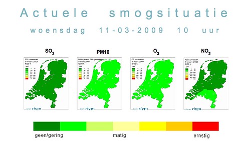
RIVM Smog Prognosis, example of opening up data with presentation layer

The results we’re looking for
What we set out to do in this project is fourfold:

  • create an overview of existing government data sources that may be made accessible, and the network of people around those data sources
  • create a manual for civil servants interested in opening up a data source they administer on how to do that, and what kind of steps to take to do that responsibly
  • create a scenario for growth, on how to move forward after the project stops
  • create two API‘s opening up two government data sources, and add some interesting visualizations, to show people what we’re talking about.

  • CFI data on education, example of data with limited export possibilities

    First impressions
    We talked to lots of people these past weeks. People from different government ministries, as well as more operational branches (such as RWS, responsible for the national roads and waterways, or RIVM, a research body for health and environment data), or organisations that are formally independent but working on government mandates (such as CBS, the central bureau for statistics). What stood out for me was that currently only two forms of data sharing seem to be on the radar of most people we talked to. One is the publication of data ‘as is’ with no explanation at all, just the database tables, usually for static or historic data. At the same time people have a lot of reservations around doing it this way as people might misinterpret the meaning of database fields. The other is the publication of data by adding their own presentation layer (and no actual access by others to the data). While interesting usually a lot of costs are involved, and data is presented in a way that made sense to the people owning the data and not necessarily to people looking at the site. API’s are basically in the middle of those two options, giving regulated but otherwise open access to the real live data. So that people can come up with uses for it that the originator of the data could not imagine, or would not put up resources for.
    There are some exceptions, that choose that middle road. There are XML interfaces e.g. to the Dutch State almanac (xml), giving all addresses of public institutions, as well as to all waste transports across the country (Web app).

    In several instances also we found eagerness to create API’s but no means to do it. That’s where our project is glad to help, even if we are not sure creating an API is our own preferred option.


    Dataportal.nl, data on traffic and water ways, extensive export possibilities for some of the data

    Different issues to deal with
    There is a number of issues that we come across in all conversations we talked to. Sometimes these issues are used to excuse inactivity, or a source of confusion as to what is possible and allowed. In general however when opening up data sources you have to always make some decisions on these issues. They are privacy, copyright, technology, organisation, and markets. I will go into these issues in more detail in other postings.

    Network forming is the way forward
    We’ve found a lot of different initiatives around opening up data in different places within government. None of them are connected or necessarily aware of each other. They do all have experiences that augment each other, and it is worth sharing them by connecting the people we met. Bringing the network together, and possibly form a core that can grow into a community of open data practices is I think the way forward. Part of the project is providing a path forward, and it will be based on network forming.


    Bringing people together around Open Data, at Ministry for the Interior. Photo: Anne-Marie IJsenbruk


    Explaining the Open Data project at ‘Open Coffee’ network meeting for civil servants interested in Web2.0. Photo: Davied van Berlo